RAILWAYS WITH ZIG ZAGS WORLDWIDE
SOUTH AMERICA
There are several railways in the Andes which have or had zig
zags, and several websites about them. General ones include:
Bo
Justusson's Andes page
Mike
Irlam's Railway Pages
Stephen
Phillips Track Diagrams
Columbia - Ferrocarril de Girardot (in Spanish). Built
1881 - 1908. 50km. Gauge 3'0" with a switchback at La Esperanza.
All trains running through La Esperanza ran backwards. The site
does not mention a zig-zag.
Link in Spanish to Columbian Railways
 Equador -
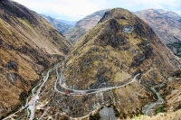
Guayaquil - Quito Railway. A Virginian, Archer Harman built
and ran the 3'6" Guayaquil and Quito Railway Company between 1897
and 1911, completing the line in 1908. The journey offered
spectacular views, as the train climbed to 3238m (10,623ft) in 80km
(50 miles), reaching its highest point at Urbina (3609m/11,841ft).
There were particularly scenic sections on the Alausi - Duran and
Ibarra - San Lorenzo sections. For railway engineering enthusiasts
the Alausi loop and the Devil's Nose (El Nariz del Diablo) double
switchback (one zigzag?) are of particular interest, gradient 1 in
18, descent 800m/1280feet. The section between
Riobamba and Alausi is in use now as a tourist railway. Until relatively
recently this line was still occasionally steam hauled.
Equador -
Guayaquil - Quito Railway. A Virginian, Archer Harman built
and ran the 3'6" Guayaquil and Quito Railway Company between 1897
and 1911, completing the line in 1908. The journey offered
spectacular views, as the train climbed to 3238m (10,623ft) in 80km
(50 miles), reaching its highest point at Urbina (3609m/11,841ft).
There were particularly scenic sections on the Alausi - Duran and
Ibarra - San Lorenzo sections. For railway engineering enthusiasts
the Alausi loop and the Devil's Nose (El Nariz del Diablo) double
switchback (one zigzag?) are of particular interest, gradient 1 in
18, descent 800m/1280feet. The section between
Riobamba and Alausi is in use now as a tourist railway. Until relatively
recently this line was still occasionally steam hauled.
Guayaquil -
Quito Railway
Peru - Cuzco - Aguas Calientes (Machu Picchu)
The line
climbs steeply out of Cuzco through a series of zig zags (six
switchbacks) which are known locally as 'El Zig-Zag'. Further on 48
km north of Cuzco there is another zig zag (double switchback).
The gauge is 3'0" (900mm) and the distance 110km.
Stephen
Phillips Track diagram, Cuzco-Macchu Picchu.
Peru - Central
Railway (Ferrocarril Central del Peru) built by Henry
Meiggs (1811-1877). Started in 1870, after the completion of
Lithgow Zig Zag, it was only completed in 1893. In the 138 mile
section between Callao (Nr. Lima) and La Oroya there were 61
bridges, 66 tunnels, 21 V-switches. It uses grades of 1 in 30 and 1
in 25 (4%), and is standard gauge.
Stephen
Phillips Track diagram, Lima - San Bartolomeo
Stephen
Phillips Track diagram, San Bartolomeo - La Oroya
Brief
History of Peruvian Railroads Interesting but no information on zig-zags / switchbacks.
Lima - La Oroya Journey Description
Peru - Ferrocarril de Centromin (former Cerro de Pasco
Railway). This railway was an extension of the Central Railway of
Peru from La Oroya to Cerro de Pasco - 83 miles. It has
a double switchback - a zig-zag c. 12km north of La Aroya.
According to Ferrocaril Central Andino Trip Details
there are 69 tunnels, 58 bridges and 6 zigzags.
In 1999 this line, and the Callao - La Oroya line together with
the La Oroya - Huancayo line was let for 30 years to a private
consortium, Railroad Development Corporation,
Railroad Development Corporation
operating as:
Ferrocarril Central
Andino
Stephen
Phillips Track diagram, La Oroya - Cerro de Pasco
Stephen
Phillips Track diagram, La Oroya - Huancayo
Trans
Andean Railway - Ran between Buenos Aires, Argentina and
Valparaiso, Chile. The section Buenos Aires - Mendoza (650
miles)(completed 1887) in the eastern foothills of the Andes was in
5'6" gauge, the section Mendoza - Los Andes (154 miles) over the
Andes was in metre gauge, and the Los Andes - Valparaiso (82
miles)(completed in the 1890s) section in 5'6" gauge. Mendoza is at
2,470 ft, the Cumbre Tunnel at 10,450 ft (the Cumbre Pass at 12,800
ft) and Los Andes at 2,669 ft. The line was completed in 1910.
There was a "Meiggs V-Switch" on the metre gauge section, much of
which was a rack railway. The metre gauge section on the Argentine
side is no longer in use.
History of the Trans Andean Railroad
Revisiting
the Transandine Railway
Argentina - Tren a Las Nubes. An all day journey of over 200 km, from Salta
to La Polvarilla. This is a remarkable work of railway engineering,
with bridges, tunnels, 2 zig zags, 2 spirals and viaducts. It
climbs from 1,187 m to 4,220 m into the Andes. The Polvarillo
Viaduct was opened in 1932 after 11 years of hard work building the
line between Argentina and Chile. The whole line opened in 1948.
The Tren a Las Nubes is the first part of the line. For more
information (in English) see their informative website, which
includes a map.
Tren a Las Nubes - with route diagram.
Chile -
Antofagasta and Iquique. There were zigzags on one or more
branches of the nitrate railways out of Antofagasta and Iquique
into the desert ranges of the Andes in northern Chile. There were 3 zigzags above Pisagua
125 miles north of Iquique. Mostly gauge 1435mm (4' 8.5").
Iquique (port)(c.20'S) is surrounded by hills. There was a
switchback about 4 miles away.
South of Iquique and north of Antofasta (port)(c.23'30"S) is the
Tocopilla al Toco railroad, 3'6" gauge, length 17 miles, 3000 ft
drop, between Barriles and the port of Tocopilla (c.22'S), gradient
4%(1 in 25) with a switchback at Reverso near Barriles.
Northern
Chile Railroad Adventure 2001
From Pisagua (port)(c.19'30"S), 125 miles north of Iquique ran a
line inland to Zapiga (94 miles) via Hospicio. On the downhill side
of Hospicio were 3 switchbacks. The line was closed in 1964.
Not a Zig Zag but sometimes described as a switchback or zigzag(s)
in the sense of horseshoe/hairpin bends:
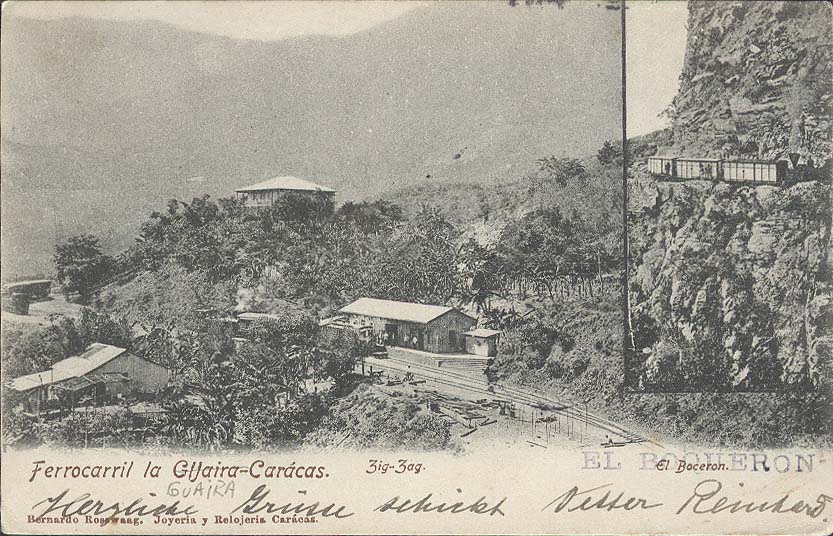
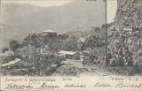 Venezuela -
La Guiara and Caracas Railway Built 1881-1883, in 3ft gauge, it climbed
3000 feet in 23 miles. It was electrified in 1920s. The description includes
zig-zags but the map shows them to be horseshoe switchbacks. Storms damaged the line
in 1951; it was closed and never re-opened.
Venezuela -
La Guiara and Caracas Railway Built 1881-1883, in 3ft gauge, it climbed
3000 feet in 23 miles. It was electrified in 1920s. The description includes
zig-zags but the map shows them to be horseshoe switchbacks. Storms damaged the line
in 1951; it was closed and never re-opened.
Updated 26 September 2013
 Equador -
Guayaquil - Quito Railway. A Virginian, Archer Harman built
and ran the 3'6" Guayaquil and Quito Railway Company between 1897
and 1911, completing the line in 1908. The journey offered
spectacular views, as the train climbed to 3238m (10,623ft) in 80km
(50 miles), reaching its highest point at Urbina (3609m/11,841ft).
There were particularly scenic sections on the Alausi - Duran and
Ibarra - San Lorenzo sections. For railway engineering enthusiasts
the Alausi loop and the Devil's Nose (El Nariz del Diablo) double
switchback (one zigzag?) are of particular interest, gradient 1 in
18, descent 800m/1280feet. The section between
Riobamba and Alausi is in use now as a tourist railway. Until relatively
recently this line was still occasionally steam hauled.
Equador -
Guayaquil - Quito Railway. A Virginian, Archer Harman built
and ran the 3'6" Guayaquil and Quito Railway Company between 1897
and 1911, completing the line in 1908. The journey offered
spectacular views, as the train climbed to 3238m (10,623ft) in 80km
(50 miles), reaching its highest point at Urbina (3609m/11,841ft).
There were particularly scenic sections on the Alausi - Duran and
Ibarra - San Lorenzo sections. For railway engineering enthusiasts
the Alausi loop and the Devil's Nose (El Nariz del Diablo) double
switchback (one zigzag?) are of particular interest, gradient 1 in
18, descent 800m/1280feet. The section between
Riobamba and Alausi is in use now as a tourist railway. Until relatively
recently this line was still occasionally steam hauled.